Clear, 65° F
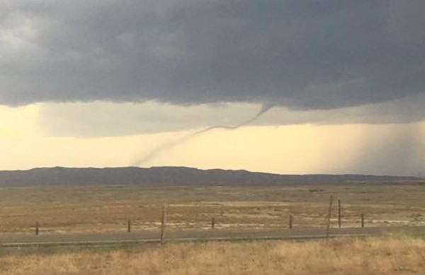
Around 6:06 p.m., a tornado was spotted 7 miles northeast of Cody and moving north at 30 mph, the National Weather Service reported. That prompted a tornado warning for northeastern Park County, including Clark and Ralston, until 6:30 p.m.
"Move …
This item is available in full to subscribers.
The Powell Tribune has expanded its online content. To continue reading, you will need to either log in to your subscriber account, or purchase a subscription.
If you are a current print subscriber, you can set up a free web account by clicking here.
If you already have a web account, but need to reset it, you can do so by clicking here.
If you would like to purchase a subscription click here.
Please log in to continue |
|
The National Weather Service briefly issued a tornado warning this (Monday) evening for Park County as part of a massive thunderstorm.
Around 6:06 p.m., a tornado was spotted 7 miles northeast of Cody and moving north at 30 mph, the National Weather Service reported. That prompted a tornado warning for northeastern Park County, including Clark and Ralston, until 6:30 p.m.
"Move to safe shelter immediately!" said the warning, cautioning that quarter-size hail was possible and predicting the storm might hit Ralston around 6:25 p.m. However, the storm reportedly weakened and moved out of the area not long after that and both the tornado and severe thunderstorm warnings for Park County were canceled.
A tornado was also reportedly spotted 14 miles southwest of Otto and 21 miles east of Meeteetse at 6:18 p.m. Multiple people in the area posted images of a funnel cloud to the National Weather Service's Facebook page. The Weather Service said the storm could also include hail the size of ping pong balls. A tornado warning remained in effect for parts of Big Horn County ― including Burlington, Otto and Emblem ― until 6:45 p.m.
Other, more dramatic tornado activity was reported in other parts of the state, including near Carpenter.
A severe thunderstorm watch remains in effect until 10 p.m. for Park, Big Horn, Hot Springs, Washakie, Natrona, Sheridan and Johnson counties.


