Cloudy, 50° F
For Park County Archives Curator Brian Beauvais, a digital, interactive map is one of the best ways to share the vast stores of local history that surrounds him at the archives.
“People …
This item is available in full to subscribers.
The Powell Tribune has expanded its online content. To continue reading, you will need to either log in to your subscriber account, or purchase a subscription.
If you are a current print subscriber, you can set up a free web account by clicking here.
If you already have a web account, but need to reset it, you can do so by clicking here.
If you would like to purchase a subscription click here.
Please log in to continue |
|
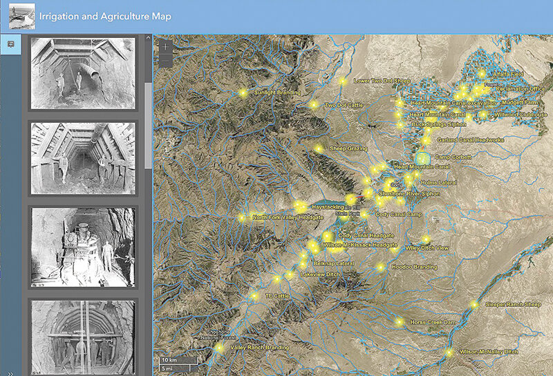
For Park County Archives Curator Brian Beauvais, a digital, interactive map is one of the best ways to share the vast stores of local history that surrounds him at the archives.
“People will come in ask about where was such and such ranch or what’s the history of my house, or where was this business,” Beauvais said. “And we can give them an address, but I think that doesn’t really communicate geographically where it is as good as a map.”
Wapiti resident Brian Clarkson, who works for the engineering firm Ardura, helped with the back-end, technical requirements of the map. Then it was up to Beauvais to throw in the data, what he said turned essentially a spreadsheet into a visual of the county overlaid with various bits of information depending on the topic.
He’s unveiled 12 maps to start, but he’s already working on more. The initial 12 include maps of Powell, Cody and Meeteetse, one of major ranches in Park County, another of major mines and even one of irrigation infrastructure.
“We already have some more in the works, but we just wanted to get these out there now, and then just get feedback from people, get more information from people and see where else we can go with this, see what other maps that people might be interested in.”
Beauvais said the maps will hopefully also be a way for people who don’t know what the county archives has to offer know more about the treasure trove of documents, maps, newspapers, stories and more.
“I sort of envision this as a kind of geographic database of history around Park County on various themes,” he said.
Beauvais added that the biggest problem is knowing what to include and what not to, as the potential is nearly endless. He’s thought about overlaying old maps onto current maps to show changes in the county, as a way of helping people visualize changes to the county over time and help shed more light on the current land use planning process.
Beauvais, a map and history enthusiast who even threw up a map collection of his travels in the county, said he’s always accepting of new ideas for future maps as well — he’s working on one on the Heart Mountain Internment Camp. Visit parkcounty-wy.gov/historical-archives/ to see the 12 maps currently available.


