Clear, 35° F
It was a wakeup call for Big Horn Basin farmers. A tunnel in the Goshen Irrigation District collapsed in July, leaving over 100,000 acres of farmland in Goshen County and neighboring Scotts Bluff …
This item is available in full to subscribers.
The Powell Tribune has expanded its online content. To continue reading, you will need to either log in to your subscriber account, or purchase a subscription.
If you are a current print subscriber, you can set up a free web account by clicking here.
If you already have a web account, but need to reset it, you can do so by clicking here.
If you would like to purchase a subscription click here.
Please log in to continue |
|

It was a wakeup call for Big Horn Basin farmers. A tunnel in the Goshen Irrigation District collapsed in July, leaving over 100,000 acres of farmland in Goshen County and neighboring Scotts Bluff County, Nebraska, high and dry.
The water didn’t begin to flow again until late August, but by then, more than 800 farmers in the area who depend on the system had their livelihoods severely impacted. Long-term repairs to the tunnel are expected to cost in the neighborhood of $15 million.
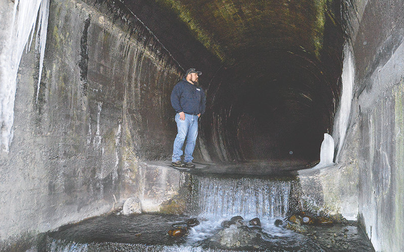
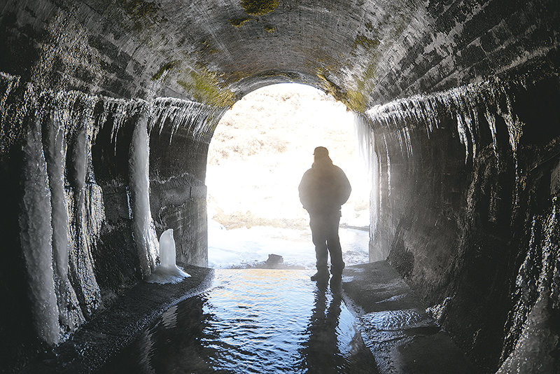
Hoping to prevent a similar disaster here, the Shoshone Irrigation District recently took a closer look at the 3.5-mile Corbett Tunnel. As with the irrigation infrastructure in Goshen County, the Corbett Tunnel is part of a system built over a century ago. The tunnel, located northeast of Cody, supplies the irrigation needs for 51,000 acres of farmland in the Shoshone and Deaver Irrigation Districts — and it’s six times longer than the one in Goshen. There’s no reason to think it couldn’t suffer a similar collapse.
At the Shoshone Irrigation District’s annual meeting this month, Ily Nunn, owner of Nu Locating, gave a presentation on ongoing efforts to analyze the soils around the Corbett Tunnel in hopes of detecting potential problems.
A graduate of Powell High School, Nunn is no stranger to the region.
“It’s neat to be back in the area and to be here supporting the community,” she said.
She’s using a combination of ground-penetrating radar and electromagnetic conductivity, tools that won’t require breaking apart any concrete.
In January, Nu Locating did a test scan of the first 150 feet of the Corbett Tunnel to determine if the tools will provide anything useful for the district. The initial readings were promising.
“We did get some really interesting data,” she said.
Nunn is facing a number of challenges with the job, and it’s taken some ingenuity to find solutions. There aren’t a lot of people analyzing soils around delicate, century-old tunnels, so Nunn is having to figure some things out as she goes along.
“It is very experimental,” she said.
The ground-penetrating radar uses what Nunn described as “pulsed radio waves.” The waves are along the same spectrum as a cellphone, but the tool uses only about 1% of the power a cellphone uses. When that wave comes in contact with different kinds of materials, it produces a reflection.
“It’s kind of like a fish finder, though it’s a little trickier to read,” Nunn said.
Ground-penetrating radar is regularly used to locate underground utilities and analyze soils on farms, and it’s pretty easy to mount the device on wheels and roll it over the ground. The tunnel, on the other hand, is in some places more than 100 feet below the surface. The signals won’t produce usable data that far into the soil, so it isn’t feasible to take readings from above along the entire tunnel’s length. That means they have to beam the signals from inside the tunnel out. Determining how to make that work is kind of like trying to figure out how to mow a lawn that grows on the ceiling.
Nu Locating’s solution was to build a spring-loaded section onto the antenna, which can be lowered and raised according to the height of the concrete over their heads. This antenna is then mounted on a cart that’s driven through the tunnel. They also built a pivot point to scan a number of angles as the cart moves along the concrete.
They also used an electromagnetic conductivity tool, which reads the conductivity of the materials as electromagnetic frequencies pass through them. The same technique is used for locating underground drums and pipes, mapping out buried landfill cells, finding contamination in soil and ground water and archaeological investigations.
While the scan in January was primarily aimed at testing the tools, the work did find a few interesting things. While the tools look for voids around the tunnel, and do not measure the integrity of the concrete itself, the tools discovered rebar in the concrete, which was not expected. Old photographs of the construction showed iron ribbings were used, but they hadn’t seen any rebar.
“That means there is more structural reinforcement in the tunnel,” Nunn said.
They found some very low conductivity in the first 25 feet of the tunnel. There could be a number of reasons, including voids or just corrosion of the rebar. It also could be that, since the dirt is much shallower at the end of the tunnel, the air above it is producing the low conductivity readings.
The rest of the scan — another 125 feet of the tunnel — didn’t show a whole lot of variance. There were a couple places that could be voids, but Nu Locating is going to look at the data and refine its techniques.
Taking what they learned from this initial test, the Nu team expects to come back in November or December to do a complete analysis from one end of the tunnel to the other.
“That test run was really successful in helping us understand that we got the right tools for the job,” Nunn said.
The cost of a complete scan has not yet been determined, but with three or four days in the field, Nunn estimated it would come in well under $50,000.
“It’s not a multi-million dollar project by any means,” she said.
And while the cost is quite heavy on the district’s budget, it’s far cheaper than the costs of a collapse to the district and the entire region. The district is looking at funding sources — including the Bureau of Reclamation — to support the analysis.


