Clear, 55° F
The new formation is likely the result of a slow-moving landslide, said the Wyoming Geological Survey’s manager of groundwater and geologic hazards and mapping, Seth Wittke. Landslides can move at catastrophic speeds, such as what is observed in …
This item is available in full to subscribers.
The Powell Tribune has expanded its online content. To continue reading, you will need to either log in to your subscriber account, or purchase a subscription.
If you are a current print subscriber, you can set up a free web account by clicking here.
If you already have a web account, but need to reset it, you can do so by clicking here.
If you would like to purchase a subscription click here.
Please log in to continue |
|
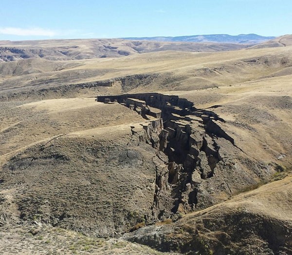
The Big Horn Mountains really are all they are cracked up to be as large portions of the southern end of the range recently moved to create a crack or “gash” that’s about 750 yards long and about 50 yards wide, according to SNS Outfitter & Guides.
The new formation is likely the result of a slow-moving landslide, said the Wyoming Geological Survey’s manager of groundwater and geologic hazards and mapping, Seth Wittke. Landslides can move at catastrophic speeds, such as what is observed in Washington state, while others can be much slower.
The size of this type of opening can vary depending on the size of the hill and the stability of the land, he said.
“A number of things trigger them, moisture in the subsurface which causes weakness in soil or geology, and any process that would weaken the bedrock or unstabilize it somehow,” Wittke said.
The challenge for the Geological Survey crew is the formation is on private property, so finding out exactly what happened would require access permission from the property’s owner.
“All we have seen is pictures since it is on private land,” said Wyoming Geological Survey’s public information specialist Chamois Andersen. “It’s hard to assess without someone on the ground looking at it.”
Interest in the newly formed “gash” spurred several thousand likes and shares on SNS Outfitter & Guides’ Facebook page since the formation appeared earlier this month.
Based on prior mapping and what’s visible in the pictures, “the gash” is likely a slump, slide or detachment, Andersen said. But, without an on-the-ground investigation, it’s difficult to determine.
“There is some speculation on the web, and with our folks too, that an early, wet, spring and summer had a lot to do with it,” Andersen said. “It is not uncommon to have slides like that.”
If a formation such as the one found in the southern end of the Big Horns is found, Wittke suggests not approaching it since it can be difficult to determine if the land is still moving or if the ground has stabilized.
Landslides and other geological changes can be reported at www.wsgs.wyo.gov so the Geological Survey crew can investigate the scene to determine the cause and find out if it’s dangerous, Wittke said.


