Clear, 63° F
Knapp said he was watching the Clark’s Fork Wednesday after a heavy rain Tuesday night, but there were minimal problems on the Wyoming stretch of the river.
“Across the state line, though, it’s causing problems,” Knapp said.
While much …
This item is available in full to subscribers.
The Powell Tribune has expanded its online content. To continue reading, you will need to either log in to your subscriber account, or purchase a subscription.
If you are a current print subscriber, you can set up a free web account by clicking here.
If you already have a web account, but need to reset it, you can do so by clicking here.
If you would like to purchase a subscription click here.
Please log in to continue |
|
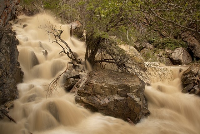
High run-off in area streams is expected to last through the end of the month, but the danger of flooding on major streams appears to be diminishing.
According to Mart Knapp, director of Homeland Security for Park County, the Shoshone River still is in the action zone, but barring heavy rain, he doesn’t expect flooding.
Knapp said he was watching the Clark’s Fork Wednesday after a heavy rain Tuesday night, but there were minimal problems on the Wyoming stretch of the river.
“Across the state line, though, it’s causing problems,” Knapp said.
While much of the snow in the mountains has melted, Knapp said two snotels are still reporting significant snow-water equivalent. The Blackwater site in the Shoshone Drainage still records 35 inches of snow with SWE of 16 inches, and the Evening Star site, which is in the Clark’s Fork drainage but near a divide with the Shoshone drainage, still reports 20 inches of snow with an SWE of 10 inches. But he said the current weather, which is bringing cool temperatures in the morning before warming in the afternoon, is allowing the snow to melt slowly.
“We’re hoping (the snowpack) keeps tapering down,” Knapp said.
High water continues to affect a few campgrounds in the Shoshone National Forest, according to forest spokeswoman Susan Douglas. The Big Game Campground is closed, as are all but nine campsites in the Wapiti Campground, and the electricity at Wapiti has been turned off.
Douglas said the Wapiti Campground was built with the expectation of high water, and was designed to minimize damage. She said the hope was to reopen the site on July 12 if the water recedes. At Big Game, though, the extent of damage to the site is uncertain, and crews will not be able to assess the damage until the water recedes.
The only other campgrounds affected are Clearwater and Three Mile, each of which has one campsite closed.
In Yellowstone National Park, most rivers are not expected to reach flood stage, according to the National Park Service, but the Yellowstone is expected to reach near-record levels at Fishing Bridge, where walkways were underwater Wednesday.
Gull Point Drive near Bridge Bay also is closed due to high water. Smaller streams in the Hayden Valley and east of Fishing Bridge are out of their banks, but are not affecting traffic or activity in the park. In a release issued Wednesday, the Park Service said high water should have little effect on park visitors.
On the other side of the Big Horn Basin, streams flowing out of the Big Horn Mountains have receded in recent days after causing some flooding in the Ten Sleep, Shell and Hyattville areas.
In Hyattville, where Medicine Lodge Creek and two forks of Paint Rock Rock Creek flow through town, flooding occurred on June 24 and again on June 29. The flooding caused some damage to bridges due to falling trees.
According to Julie Greer, Hyattville’s postmaster, some basements and crawl spaces flooded, but no homes were lost, and the water has receded.
On Wednesday, the National Weather Service issued flood warnings for the smaller creeks and rivers in both Big Horn and Park counties.


