Partly Cloudy, 35° F
The cracks in the road — also known as Wyo. Highway 296 — are at milepost 26.1 and have been clearly marked with warning signs, the Wyoming Department of Transportation says.
Two other slides have occurred near the Chief Joseph Scenic …
This item is available in full to subscribers.
The Powell Tribune has expanded its online content. To continue reading, you will need to either log in to your subscriber account, or purchase a subscription.
If you are a current print subscriber, you can set up a free web account by clicking here.
If you already have a web account, but need to reset it, you can do so by clicking here.
If you would like to purchase a subscription click here.
Please log in to continue |
|
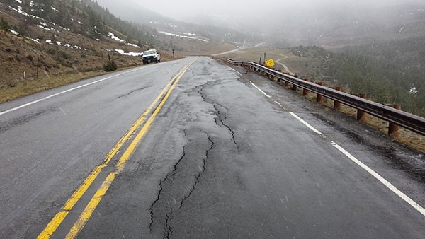
Moisture has caused the ground to slide near Dead Indian Creek and led to cracks in the Chief Joseph Scenic Highway.
The cracks in the road — also known as Wyo. Highway 296 — are at milepost 26.1 and have been clearly marked with warning signs, the Wyoming Department of Transportation says.
Two other slides have occurred near the Chief Joseph Scenic Highway’s intersection with Wyo. Highway 120, at about milepost 45.5, but neither of those slides have impacted the highway yet.
“It is shaping up as an interesting spring,” said Shaun Emmett, WYDOT heavy equipment operator of Cody.
WYDOT staff in Cody and Dubois are monitoring a total of six different moisture-related slides between the Chief Joseph highway and Togwotee Pass (U.S. Highway 26/287).
The three slides on Togwotee Pass are located at mileposts 40.6, 40.2 and 9.4. Mileposts 40.6 and 40.2 are near the Shoshone National Forest boundary. Those slides have caused movements in the highway — one fell 4 inches on Thursday — and they’ve been marked with warning signs for drivers, WYDOT says. The milepost 9.4 slide is located at a spot known as Rosie’s Ridge.


