Mostly Cloudy, 41° F
The Wyoming Public Lands Initiative’s Park County Advisory Committee has a number of classification options it could recommend, ranging from wilderness (which would prohibit mechanized travel) or a number of non-wilderness designations that …
This item is available in full to subscribers.
The Powell Tribune has expanded its online content. To continue reading, you will need to either log in to your subscriber account, or purchase a subscription.
If you are a current print subscriber, you can set up a free web account by clicking here.
If you already have a web account, but need to reset it, you can do so by clicking here.
If you would like to purchase a subscription click here.
Please log in to continue |
|
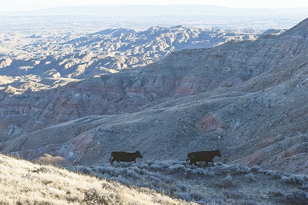
A committee of local residents mulling how the Wilderness Study Area (WSA) in the McCullough Peaks should be managed remains in fact-finding mode.
The Wyoming Public Lands Initiative’s Park County Advisory Committee has a number of classification options it could recommend, ranging from wilderness (which would prohibit mechanized travel) or a number of non-wilderness designations that allow vehicles.
The committee was appointed by Park County commissioners as part of the Wyoming Public Lands Initiative, “a voluntary project initiated and led at the county level that will culminate in legislation forwarded to Wyoming’s Congressional delegation,” according to the Wyoming County Commissioners Association.
At a Wednesday evening meeting, committee facilitator Tara Kuipers suggested the group study area maps, list unanswered questions and consider potential outcomes.
Cody Bureau of Land Management personnel, Delissa Minnick, field manager and Paul Rau, outdoor recreation planner, attended the meeting to answer committee questions.
One question concerned the mineral rights within the 24,570-acre WSA.
“Within the WSA boundary, there are no (mineral) leases,” Rau said.
The WSA is currently closed to mineral development, Minnick said. So, if the study area was declared actual wilderness, it would not impact mineral development.
Meanwhile, the current 5.1 miles of primitive road would be unavailable to motorized vehicles if the WSA became wilderness, Minnick said.
Two grazing allotments fill the WSA and grazing livestock could continue to be allowed in a wilderness area, Minnick said.
If declared a wilderness area, the only initial costs would be signs proclaiming it a wilderness area, she said.
“If it’s wilderness, it’s wilderness,” said committee member Jenny DeSarro, who represents conservation. However, DeSarro also noted there are also different designations to choose from.
The Wyoming Congressional Delegation want local input to select the best option, Kuipers said.
An entirely new designation could be created, though committee chairman Bucky Hall said it would be easier to use a designation from the standardized list.
“It will be a heck of a lot less work,” Hall said.
Options could include a national scenic area, that would protect the land’s natural environment while allowing recreation that would be banned in wilderness; a national conservation area, which would protect the land, but allow uses not allowed in wilderness; or a national recreation area, allowing recreation while protecting natural resources.
In 1991, the Bureau recommended that Congress turn 8,020 acres of the WSA into wilderness.
Committee member Karinthia Harrison, representing the general public, suggested the recommendation be expanded to include Deer Creek Draw; the draw is within the WSA.
“Tons of roads in the Big Horns. Is it too much to have something protected up here?” Harrison asked.
John Gallagher, representing non-motorized recreation, was unable to attend last week’s meeting, but told the Tribune later that the WSA has plenty of trails suitable for biking and hiking. Gallagher said he would like to see the access to those trails maintained like the rest of the Peaks.
He believes people approve of the WSA’s current management. “We (non-motorized users are) not looking for any major changes at all.”
The WSA has existing roads, Gallagher said. As long as motorized users stick to the designated trails, it’s OK with him — and 99 percent motorized folks stick to the trails. If the trails are closed to motorized activity, some will ride there anyway. “If you build a good trail system they’ll use it,” he said.
Dustin Rosencranse, representing motorized recreation, said his users would “like to see a nice motorized riding area.” But Rosencranse said he knows that will not happen. He noted the committee’s goal is to write a draft bill for Congress that will pass.
Rosencranse said he would prefer to see a portion of the WSA released back to the Bureau so as to become part of its management plan. Then, that land could be managed with public input; Park County residents could decide if they want motorized travel or not.
If approximately 15,000 acres of the WSA were released to the Bureau, the remaining 8,000 acres could be designated wilderness, Rosencranse said.
As it is now, the WSA has remained in limbo for 31 years, barring any kind of motorized travel, including mountain bikes, Rosencranse said. If snow continues to fall this winter, it could result in very tall grass drying by July. If there is a wildfire, fire trucks would be barred in the WSA.
The motorized recreation community is not determined to increase riding trails in Park County, Rosencranse said: They just want to retain what they now have.
Rosencranse said he’s willing to listen to others. “My door is open. I’ll talk to anyone who wants to visit about this,” he said.
Other issues
Some of last week’s discussion included talk about wild horses.
Roughly half of the McCullough WSA is a part of the 120,344-acre wild horse herd management area (HMA). However, Minnick said the HMA should have no affect on the WSA. The land is managed for mustangs, other wildlife, cattle, etc.
Water is always a concern, Minnick said in response to a question. But the Bureau has no water improvement plans in the WSA. If a water project was proposed there or on any public land, it would require National Environmental Policy Act compliance, Minnick said.
Whatever designation or decision is reached, the HMA will remain, Hall said.
There are no sage grouse core areas or sage grouse leks in WSA, according to the Bureau.
The portion of the Paleocene-Eocene Thermal Maximum in the Peaks — a geologic record of a significant warming event from millions of years ago — is an area of scientific concern, Rau said. However, it is protected under the Bureau’s Resource Management Plan and is southwest of the WSA, the Bureau says.
DeSarro noted a section of state land sits in the middle of the WSA. The state owns both the surface and mineral rights to the 640-acre parcel, Minnick said. The state could sell the land, but that is unlikely.
Kuipers suggested the committee explore methods to inform the public about their work.
DeSarro said a Peaks fact sheet should be placed on the website; Hall said he would discuss including more information on the Initiative’s website with Park County’s information technologist.
The group’s website can be reached by visiting http://tinyurl.com/ParkCountyWSAs.


